GEOGATE

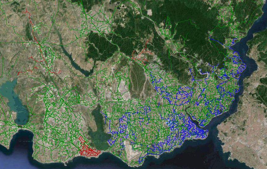
Intelligent Engineering Solutions

GEOGATE – GISAS

Bidirectional Integration between GIS databases and power system analysis Software database.

Try Now Download PDF
screenshot

GEOGATE-AutoCorrect

search algorithm/engine, enhancing its capabilities and facilitating swift access to pertinent information. This amalgamation of technology epitomizes the dedication to innovation that underscores the GEOGATE-GISAS platform.

Cable Sizing and Route Optimization

(LV and MV Networks): Within both low-voltage (LV) and medium-voltage (MV) networks, this capability offers cable sizing and route optimization, enhancing the efficiency and reliability of network components.

Integration with Operational Systems

By seamlessly interfacing with OSOS/AMR/AMI/MDM/CSI systems, this feature enables the assimilation of load profiles into both the GEOGATE database and PSA software databases, ensuring a comprehensive and up-to-date dataset.

iphone

GEOGATE 5.1 – GISAS serves as a preeminent and intelligent interface

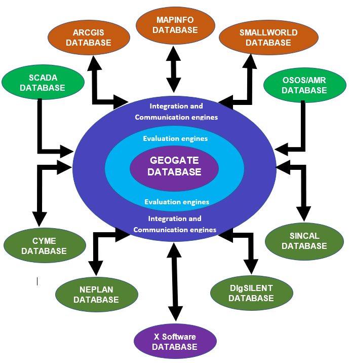
seamlessly bridging the gap between leading GIS software applications such as ARCGIS, MAPINFO, and SMALLWORLD, and the prevalent PSA (Power System Analysis) software utilized within distribution networks, encompassing SINCAL, NEPLAN, CYME, and DIgSILENT. This sophisticated gateway facilitates robust data integration and exchange, catering to the intricate requirements of modern power system analysis and geospatial information management.

The GEOGATE – GISAS engine encompasses a spectrum of ten distinct applications,

each meticulously designed to cater to intricate operational requirements:

  • 1- Bidirectional GIS-PSA Database Conversion: Facilitating seamless data interchange, this application enables bidirectional conversion between GIS and PSA software databases, ensuring harmonious integration of geospatial and power system information.
  • 2- Bidirectional Full Offline Update: This sophisticated feature empowers comprehensive offline updates encompassing additions, deletions, geographical alterations, and electrical modifications within both GIS and PSA software databases, fostering data consistency.
  • 3- Bidirectional Full Online Update: Operating in real-time, this application facilitates instantaneous bidirectional updates involving additions, deletions, geographical changes, and electrical modifications, ensuring synchronized databases between GIS and PSA software even during dynamic scenarios.
  • 4- Bidirectional Incremental Layer Update: Addressing the need for targeted updates, this functionality enables the seamless addition of items through incremental layer updates, enhancing efficiency while maintaining data accuracy.
  • 5- Integration with Operational Systems: By seamlessly interfacing with OSOS/AMR/AMI/MDM/CSI systems, this feature enables the assimilation of load profiles into both the GEOGATE database and PSA software databases, ensuring a comprehensive and up-to-date dataset. Integration with Operational Systems: By seamlessly interfacing with OSOS/AMR/AMI/MDM/CSI systems, this feature enables the assimilation of load profiles into both the GEOGATE database and PSA software databases, ensuring a comprehensive and up-to-date dataset.
  • 6- Integration with Feeder Analyzers Database: Seamlessly interfacing with feeder analyzers' databases, this application facilitates the allocation of analyzer load profiles to the loads within the PSA software database. This integration ensures a harmonious amalgamation of data for comprehensive power system analysis.
  • 7- Integration with SCADA/DMS/OMS Systems: By interfacing with SCADA/DMS/OMS systems, this feature enables the real-time update of switching statuses for breakers and switches within both the PSA software and GIS software databases, ensuring accuracy and currency of operational data.
  • 8- Cable Sizing and Route Optimization (LV and MV Networks): Within both low-voltage (LV) and medium-voltage (MV) networks, this capability offers cable sizing and route optimization, enhancing the efficiency and reliability of network components.
  • 9- Overhead Line Conductor Sizing and Optimization (LV and MV Networks): Addressing overhead line conductor specifications, this functionality optimizes sizing and configuration within both LV and MV networks, ensuring optimal performance and load management.
  • 10- Optimized Geographical and Electrical Connection: This application pertains to identifying the optimal geographic and electrical connection points for connecting MV or LV loads to the network. The optimization process encompasses factors such as transformer sizing, cable routes, and overhead line routes, leveraging data sources like Google Maps and HERIS maps for comprehensive and informed decision-making
geogate-database

GEOGATE stands as an intelligent and highly adaptable solution

primed for customization to seamlessly align with your unique requirements. Its implementation and establishment demand minimal time investment, leveraging attributes, layers, fields, and data formats inherent in your GIS tables.

The process of tailoring GEOGATE to match your company's GIS data structure, format, and attributes, culminating in the delivery of a fully functional and feature-rich solution, can transpire with remarkable efficiency, often spanning a mere 7 to 30 business days.

At its core, GEOGATE represents a dynamic solution that orchestrates automatic mapping of your GIS layers and tables. This orchestration yields up-to-date and precise distribution network models, poised for strategic planning and operational analyses within your PSA software environment.

Central to the prowess of GEOGATE-GISAS is its integration of the advanced, rapid, and intelligent "GEOGATE-AutoCorrect" search algorithm/engine, enhancing its capabilities and facilitating swift access to pertinent information. This amalgamation of technology epitomizes the dedication to innovation that underscores the GEOGATE-GISAS platform.

iphone-ipad

Electrical Data Validation

Proficiently evaluates GIS data from an electrical perspective, utilizing attributes like cable cross-sections, equipment nominal and operating voltages, electrical loops, equipment ratings, relay and CT sizes, and more.

Disconnectivity and Mis-Connectivity Resolution

Automatically identifies, reports, and remedies instances of disconnectivity and mis-connectivity within both GIS and PSA software databases.

Voltage Validation and Correction

Validates section voltages connected to nodes, reporting and rectifying mal-connected sections within GIS and PSA databases.

Protection for Unprotected Transformers

Identifies MV/LV transformers lacking protection, then generates and sizes associated busbars, switches, breakers, CTs, and fuses within both PSA and GIS databases, bridging incomplete GIS data.

GEOGATE-AutoCorrect represents an elevated echelon of data validation and search engines, adeptly verifying both electrical and geographical coordinate data within the GIS and GEOGATE databases. The capabilities of GEOGATE-AutoCorrect encompass a comprehensive range of functions that underscore its prowess as an advanced data validation and search engine:

each meticulously designed to cater to intricate operational requirements:

  • 1-Electrical Data Validation: Proficiently evaluates GIS data from an electrical perspective, utilizing attributes like cable cross-sections, equipment nominal and operating voltages, electrical loops, equipment ratings, relay and CT sizes, and more.
  • 2-Disconnectivity and Mis-Connectivity Resolution: Automatically identifies, reports, and remedies instances of disconnectivity and mis-connectivity within both GIS and PSA software databases.
  • 3-Voltage Validation and Correction: Validates section voltages connected to nodes, reporting and rectifying mal-connected sections within GIS and PSA databases.
  • 4-Protection for Unprotected Transformers: Identifies MV/LV transformers lacking protection, then generates and sizes associated busbars, switches, breakers, CTs, and fuses within both PSA and GIS databases, bridging incomplete GIS data.
  • 5-Source-to-Downstream Validation: Traces from source/feeders downstream, validating equipment rating, electrical and operating data, and nominal voltage along the path.
  • 6-Feeder/Subfeeder Validation: Traces source/feeders downstream, ensuring correct feeder IDs and equipment connectivity throughout the network.
  • 7-Island Area Detection: Distinguishes islanded areas and suggests optimal connection points for reintegration into the energized grid.
  • 8- Busbar Unification: Integrates split busbars within GIS while constructing the electrical network in PSA software.
  • 9-Transformer Load Creation: Generates loads for MV/LV transformers based on transformer rating or OSOS/AMI/AMR data.
  • 10- Branch Pole Handling: Splits lines and cables at branch poles for accurate network representation.
  • 11- Intermediate Connection Points: Connects end-of-line/cables to intermediate points of other lines/cables at the same voltage level, customizable by the user.
  • 12-Disconnected Line/Cable Handling: Identifies disconnected lines/cables, reconnecting them to the nearest energized components.
  • 13-Disconnected Busbar Handling: Detects disconnected busbars and links them to the nearest busbars or transformers.
  • 14-Duplicates Identification and Correction: Distinguishes and rectifies duplicate equipment names and geographic locations when transferring data to the PSA software database.
  • 15-Line/Cable Splitting: Splits lines/cables at switch/breaker/transformer/fuse points for accurate modeling.
  • 16-Duplicate Transformer Handling: Identifies duplicated transformers at the same location with different IDs, integrating them into the network.
  • 17-Electrical Loop Resolution: Detects, reports, and resolves electrical loops.
  • 18-Geographical Loop Resolution: Identifies, reports, and resolves geographical loops.
  • 19-Busbar Splitting: Splits busbars at switch/breaker/fuse points to maintain accuracy.
  • 20-Integration Status Verification: Checks the integration status of equipment within the GIS.
  • 21- Relay Automation: Automatically creates relays in PSA software for breakers lacking relays/CTs in GIS, computing primary pickup currents and CT ratios.

These capabilities collectively define GEOGATE-AutoCorrect as a sophisticated and advanced tool for validating, enhancing, and optimizing electrical and geographical data within both GIS and PSA software domains.

The integration and database interface functionalities of GEOGATE with both GIS software and power system analysis software databases are defined by the following parameters:

GEOGATE Database and Interface:

  • GEOGATE's database accessibility encompasses multiple formats, including Microsoft Access (*.mdb, *.accdb), Oracle, SQL, and PostgreSQL. The deployment options for the GEOGATE database are versatile: it can be installed as a server utilizing SQL, PostgreSQL, or Oracle databases, or as a client employing Access or PostgreSQL databases.

GIS Software Database Compatibility:

  • GEOGATE seamlessly interfaces with diverse GIS software database formats, including Shapefile (.shp), Personal Geodatabase (.mdb), Geodatabase (.gdb) within Esri's ArcGIS ecosystem, MapInfo File (.tab), MapInfo Interchange Format (.mif), dBASE DBF (.dbf), Delimited ASCII (.txt), and comma-delimited CSV (.csv), in addition to SQL and Oracle databases.

PSA Software Database Compatibility:

  • In the realm of Power System Analysis (PSA), GEOGATE accommodates a spectrum of database/file formats, comprising Access Database (.mdb), SQL, Oracle, XML, sxst, CIM (Common Information Model), pfd, dz, nepprj, and dgs/ndt.

This broad compatibility matrix underscores GEOGATE's adaptability, allowing seamless interaction with various databases and software systems, culminating in streamlined data exchange and integration across the GIS and power system analysis domains.

GEOGATE encompasses a spectrum of additional features that can be seamlessly integrated into the basic package, tailored to specific client requisites:

1-Automatic HV/MV Substation Creation:

  • Facilitates the automatic generation of HV/MV substations within both GIS and PSA software. This process is orchestrated through streamlined input data—via Excel or Access—that outlines substation locations, busbar quantities, incoming/outgoing counts, and busbar and substation types.

2-Geographical Single Line Diagrams: Generates

  • single-line diagrams in both GIS and PSA software, utilizing geographical substation data to create accurate visual representations.

3-Voltage-Based Single Line Diagrams:

  • Creates single-line diagrams in both GIS and PSA software, this time based on substation voltage levels and the spatial distribution of sources/feeders.

4-Efficient GIS-to-PSA Update:

  • Ensures a rapid update from GIS to PSA software, streamlining the process when GIS data exists in formats such as gdb, mdb, Oracle, SQL, MIF, CSV, or TXT, and the GIS software is ARCGIS or MAPINFO.

5-Results and Reports Export:

  • Offers the ability to export analysis outcomes and reports to formats such as Excel, Access, Word, and PDF.

6-Intranet/Web Application:

  • Extends GEOGATE's capabilities to an intranet/web environment, enabling the presentation of validation results and reports through a web interface.

7-Web-Based Electrical Data Reports:

  • Provides web/intranet-based reports for electrical data, showcasing PSA software analysis results in a customizable and client-specific design.

8-GIS-Based Electrical Calculation Results:

  • Integrates electrical calculation results—such as load flow, voltage drop, short circuit analyses, load allocations, and relay coordination—into GIS as distinct layers and into the web interface as customizable reports, including voltage, power, current, and device settings.

9-Comprehensive Integration Reports:

  • Prepares exhaustive reports detailing the integration process, GIS data validation, and equipment corrections. These reports are made accessible via the web and encompass all equipment categories.

10-Web Service Functionality:

  • Offers a robust web service feature, permitting the extraction of data or results from the GEOGATE database, as well as the updating of data within it. This customizable feature spans all GEOGATE fields and functionalities.

11-Web/Intranet Interface:

  • Facilitates access to GEOGATE's suite of features and its database through a user-friendly web/intranet interface, ensuring flexibility and ease of use.
  • These additional features amplify the utility of GEOGATE, tailoring it to meet the unique demands of clients, while enhancing functionality, accessibility, and reporting capabilities.

An illustrative instance of a successful integration showcases the remarkable efficiency and accuracy of GEOGATE:

  • GEOGATE serves as an exceptional integration gateway, exemplified by its ability to validate, correct, and seamlessly transfer extensive GIS data to a PSA software database. For a utility's MV GIS network, featuring an impressive array of over 450,000 equipment components—including 20,000 overhead lines/cables, 50,000 switches, 25,000 breakers, 10,000 fuses, 250,000 buses, 15,000 transformers, 80,000 joint cables, 110 HV/MV substations, 800 feeders, and 500 capacitors/reactors—this integration process is completed in a mere 60-70 minutes within an SQL, PostgreSQL, and Oracle database environment. Similarly, in an Access database environment, the process takes only 120 minutes, while ensuring an impeccable 100% accuracy rate.
  • Furthermore, the update module of GEOGATE unveils an array of options and features that contribute to its efficiency. For instance, updating a GIS file to a PSA database with 10,000 modifications—encompassing additions, deletions, geographical adjustments, and electrical modifications—is executed in just 25 minutes within SQL , PostgreSQL and Oracle databases, and a commendable 60 minutes within Access databases, all while maintaining a flawless 100% precision level.
  • This scenario showcases the exceptional speed, accuracy, and robustness of GEOGATE's integration capabilities, underscoring its role as an indispensable tool for organizations seeking swift and precise data synchronization between GIS and PSA software domains.

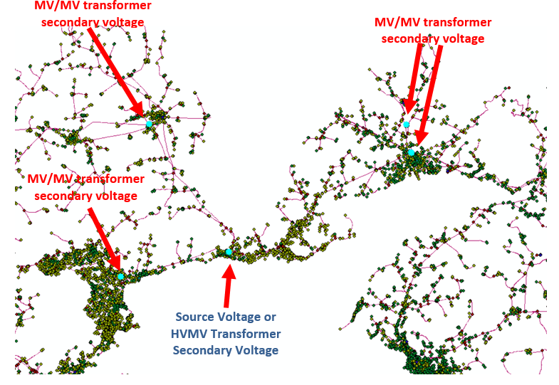
The GEOGATE51 Source to Load Voltage and Feeder ID Tracing Algorithm is an advanced and sophisticated tool designed to trace voltage paths from source to load and to identify and rectify discrepancies in feeder IDs and sub-feeder IDs. Its operation is grounded in specific prerequisites and yields several valuable benefits:

Algorithm Prerequisites:

Voltage Data: The algorithm primarily requires voltage information from sources (HV/MV transformers' secondary side voltages) and MV/MV transformers' secondary side voltages.

Equipment Connectivity: The algorithm operates most effectively when there is connectivity between equipment, with any disconnections between Line/Cables being minimal, typically less than 10 cm.

Benefits of the Algorithm:

  • Voltage Tracing and Correction: The tracing algorithm systematically follows the voltage path from the source to the load, identifying incorrect voltages that do not align with upstream voltage data. Subsequently, it reports and rectifies these discrepancies.
  • Voltage Tracing and Correction: The tracing algorithm systematically follows the voltage path from the source to the load, identifying incorrect voltages that do not align with upstream voltage data. Subsequently, it reports and rectifies these discrepancies.
  • Feeder and Sub-Feeder ID Correction: The algorithm extends its functionality to the realm of feeder and sub-feeder IDs. It identifies sections lacking proper feeder and sub-feeder IDs or those with erroneous feeder IDs. Subsequently, it fills in and corrects these IDs, enhancing the overall accuracy of network representation.
  • Diverse GIS Data Compatibility: The algorithm can seamlessly work with GIS data in various formats and software systems, including ARCGIS, MAPINFO, and Smallworld, as well as geodatabase formats such as gdb/mdb, SQL, PostgreSQL, and Oracle.
  • The GEOGATE51 algorithm's prowess in swiftly tracing voltages, rectifying feeder IDs, and ensuring data accuracy underscores its value as an indispensable tool for optimizing network integrity and reliability within complex GIS and PSA environments.
iphone-ipad

Watch Our Product Video

view more...

It's time to change your mind

Used by over 100 companies.
We say you won’t look back.